GAWLER CHALLENGE


Uncovering hidden minerals at Gawler region, South Australia
Integrating Geochemistry, Geophysics and Geographic Information System for mineral exploration.
The Challenge by the Government of South Australia, “the Gawler Global Challenge” was launched on the 2nd March, 2020. Its aim was to give an opportunity to the world scientific community of looking and establishing best mineral exploration models that can uncover hidden mineral deposits in that part of the world. There was no specific technique proposed and interested people were invited to use any technique (s) of their choices.
STUDY AREA
South Australia
The data provided by the client covers region of South Australia which includes the Gawler Craton as defined by GCS_GDA_1994 coordinates: 129 West, 141.East, -38.53 South and -26. North.

DATASET
South Australia
The client has some working mineral exploration models (http://www.energymining.sa.gov.au/minerals/geoscience/geology/gawler_craton) for the Gawler craton that include;
-
FeO-Cu-Au-Ag±U (haematite- and magnetite-dominated styles) (Olympic Cu-Au Province, e.g. Olympic Dam, Prominent Hill, Hillside, Moonta, Carapateena Prospect);
-
Iron ore as massive hematite deposits by supergene enrichment, (e.g. Iron Monarch, Iron Duke, Wilgerup);
-
Iron ore as magnetite and hematite skarn/replacement styles (e.g. Peculiar Knob, Snaefell, Wilcherry Hill);
-
Intrusion-related Au (Central Gawler Gold Province, e.g. Tarcoola, Tunkilla Prospect, Barns Prospect, Weednanna Prospect);
-
Shear-hosted Cu, Au, U (e.g. Cairn Hill);
-
Shear to unconformity-related U (e.g. Driver River in central Eyre Peninsula);
-
Orogenic Au (e.g. Challenger);
-
Volcanogenic Pb-Zn-Ag (e.g. Menninnie Central and Telaphone Dam Prospect) and Cu-Fe (e.g. West Doora)
-
Epithermal-style Ag-Pb-Zn (e.g. Paris) and Au-Ag-Pb-Zn (e.g. Parkinson Dam);
-
Sedimentary-hosted Pb-Zn (Hutchison Group, e.g. Miltalie Mine, Mangalo Mine, Atkinson’s Find, Smithams);
-
Graphite (e.g. Uley Graphite Mine, Kookaburra Gully, Koppio, Wilclo South) and
-
Metasomatic talc, magnesite and jade (Katunga Dolomite).
-
The possible mineral exploration models reported include;
-
VHMS deposits (Hall Bay Volcanics, Oakdale prospect southern Eyre Peninsula);
-
Late Archaean komatiitic and magmatic intrusive-hosted Ni-Cr-PGE (Lake Harris Greenstone Belt, Aristarchus);
-
Magmatic Ni-Cr-Cu sulphides and PGE (Fowler and Christie Domains);
-
Unconformity and Palaeochannel U and Au (e.g. Corunna Conglomerate);
-
Diamondiferous kimberlite;
-
Intrusion-related W and Sn (e.g. Moonbi W prospect, Zealous Sn prospect) and
-
Fe-Ti-V styles (e.g. MalboomaAnorthosite Complex, Wigetty prospect)
From the above models, one can generalize that multiple mineral exploration models characterize the South Australian geology that include igneous (intrusion and volcanic) related, sedimentary related and metamorphic related models.
RESULTS
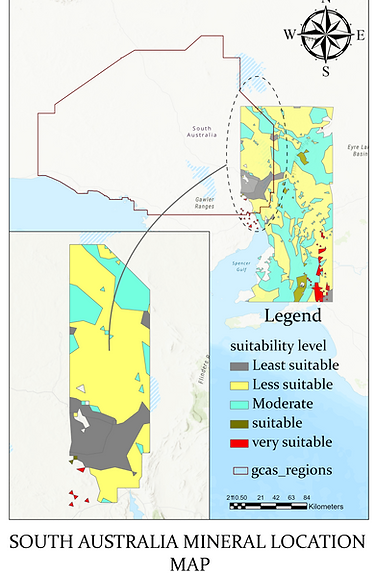
SOUTH AUSTRALIA SUITABILITY MAP

Suitability Map
Results and Discussion
Data classifications followed by assigning weights to the various classified data enabled favorable (suitable) areas to be revealed as follows:
-
Most favorable (very suitable) area / zone; this is defined by a N-S to NNE-SSW trending pattern. It is shown in red color. In terms of size, it is thinner towards the north (at the tune of 10km wide) and thicker due south at the tune of more than 3 folds and tends to follow the granite outline. The total strike length of the most favorable area is of the order of 200km and has a total area of about 4,005km2. This area includes a small most favorable (very suitable) zone found on the western part of the central part of the study area.
-
The second favorable (suitable) zone; this is defined by a relatively thinner zone of the order of 60km long or more strike length with a width of the order of less than a kilometer to more than 8km. Isolated patches of a suitable zone are found further north of the study area in two isolated patches. This suitable area is about 4,180km2 in total.
-
The third favorable (moderate) zone (Fig. 6), is defined by light blue color. This zone, occupies a total area of the order of 80,564km2.
-
The fourth and fifth favorable (less suitable and least suitable) zones are respectively of the order of 101,880km2 and 10,773km2. They are defined by yellow and gray colors respectively.
It can be generalized that all the favorable (suitable) areas (zones) trend N-S meaning that the N-S trend is related to factors that are controlling economic mineralization in the study area.

EVIDENCE FROM SILVER DEPOSITS
By plotting all the Au mineralization location points provided, the highest concentration is also defined by a N-S pattern

EVIDENCE GOLD DEPOSITS
By plotting all the Gold mineralization location points provided, the highest concentration is also defined by a N-S pattern

EVIDENCE FROM COPPER DEPOSITS
By plotting all the Copper mineralization location points provided, the highest concentration is also defined by a N-S pattern

CONCLUSION
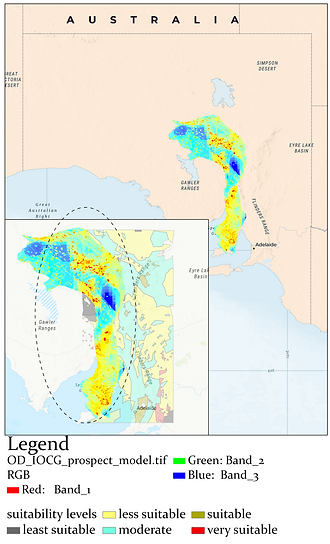
Results have shown that the prospective zones / areas are basically narrow, typically ranging between 10 - 50km wide and extending for hundreds of kilometers in a N-S to NNE-SSW trend. This is exemplified by the suitability map obtained from this work out of the data given by the Client. Likewise, the Fe-oxide-Cu-Au (IOCG) zone obtained from other sources (provided by the client) is parallel with the proposed potential (most suitable) area. Both zones are about 50km apart. It tells us therefore that the most prospective or mineral potential zones in the study area trend N-S to NNE-SSW as indicated by the established model and as supported by selected minerals / elements such as gold, silver and copper deposit localities. This is like a puzzle because most of the rocks in the study area are trending NW-SE , meaning that the mineralization pattern is not largely controlled by the lithological units-leave alone the conspicuous and pervasive mafic dykes that trend NW-SE suggesting regional structural control. Based on the established suitability maps, the NW-SE structural trend has nothing to do with the mineralization observed in the study area. It means therefore that relatively younger structures from relatively younger geological processes could be responsible for the formation of regional N-S to NNE-SSW mineral (deposit) trends. The main task here is to establish the structural model that would support the interpretation or argument that indeed the mineralization is structural controlled.
Although the folds are far from being symmetrical, they somewhat define a characterized by a N-S to NNE-SSW axial surfaces or hinge zones which could be defining locus of hydrothermal fluids passage. This is only possible if relatively intensive fracturing occurs along such hinge zones. In our interpretation, we consider that the Neo-proterozoic granite (of the Delamerian Orogeny) is a relatively younger event that intruded at the time when brittle or semi-brittle sedimentary and other continental materials were already folded. That intrusive event intensified the folding and fracturing along hinge zones. Further, this relatively younger granitic intrusion became an engine of heat which mobilized mineralizing fluids from different sources into pre- and syn-fractures / weak zones.
In order for mineralizing fluids to focus passing through N-S to NNE-SSW fractures, it implies that such a N-S to NNE-SSW trend defines a direction of minimum principal stress axis (σ3) where most fluids would flow through. In other words, the maximum principal stress axis, σ1 (which also corresponds to compressive stresses) would be perpendicular to σ3, (σ3 in our case is defined by N-S to NNE-SSW trend). In this case σ1 corresponds with the pushing effect of the intruding granite. This, in our context, is oriented E-W (Fig. 12, 13). In other words based on this interpretation, there can be no economic mineralization oriented in an E-W direction in this study area, particularly around the vicinity of the Neo-proterozoic granite of the Delamerian Orogeny. Intermediate orientations defined by components of σ3 such as σ3cosθ (where θ= angle between σ3 and the intermediate directions) could still hold mineralization at different magnitudes mainly as a function of the value of angle θ (Fig. 13), i.e. the larger the angle the less the amount of mineralization and vice versa.
Fe-oxide-Cu-Au (IOCG) zone

Regional Total Magnetic Intensity, TMI map provided by the client. The map shows diffuse near asymmetric regional folds.
Granite Intrusion

THEREFORE.....
The fact that granitic intrusion is involved in the mineralization and the fact that the NW-SE trending dykes are older than the granites, several possibilities can be deduced:
-
Fe, Ni, Cu within the mafic dykes along with sulphides (both dyke related and sedimentary in origin) could have been remobilized by heat from younger granites leading to concentration of economic Ni-Cu sulphides along N-S to NNE-SSW trending axial planes / surfaces or hinge zones. Mobilization of sedimentary sulphides and local deposition of the same has been proposed by various scholars in various world Ni-Cu sulphide deposits such as is the case for the Kabanga Ni-Cu Sulphide deposits (e.g. Evans et al.,1999; 2000);
-
Iron-Copper-Gold mineralization is likely along the N-S to NNE-SSW trending axial surfaces and tends to curve anticlockwise towards the southern part. This is supported by the fact that all locations for copper, gold, silver ± iron show highest concentration along the N-S to NNE-SSW trend east of the area demarcated as granitic intrusion (e.g.) and;
-
Hydrothermal related minerals such as HFS-REEs could have been deposited along or within N-S to NNE-SSW trending axial surfaces and within the margins of the granite (s).
Therefore, three key minerals exploration models are proposed in this area (the Gawler area):
-
Fe-Ni-Cu sulphides particularly in the vicinity of the contacts between mafic dykes and granites. The Fe-Ni-Cu sulphides could be within sedimentary rocks between mafic dykes to the west and granites to the east;
-
Fe-Cu-Au (with As) just on the margins of the granites, particularly along N-S to NNE-SSW trending weakest zones such as N-S to NNE-SSW trending hinge zones; and
-
HFS-REEs along or on the margins of the Neo-proterozoic granite of the Delamerian Orogeny.
While the first two models have been supported by data, the third model is more descriptive and knowledge driven interpretation.
METHODOLOGY
GIS Multi-criteria Decision Analysis

CRITERIA USED

Lithologic units
Granite intrusion : 5,
Dolerite dykes : 4,
Continental materials : 3,
Sedimentary materials : 2, and
All other available rocks in the study area were assigned a score of 1.
5 - Most suitable
1 - Least Suitable

Faults / Lines
Fault position accurate : 5
Faults approximation : 4
Fold axial position accurate :3
Dyke vein narrow : 2
Other lines/faults : 1
5 - Most suitable
1 - Least suitable

Heavy Metal
Heavy metal deposits


